Why the day is divided to 24 hours? who decided where one country begins and another ends? and why are we wearing undies under our pants?
lots of questions fly around us in the life of the 21 century, the process of thinking "why am i ,doing this" or "why it is like that" called skepticism but where does it come from? and more interesting where does it go.
the skeptic way of thinking developed in ancient greece in a city name "skepsis", and from there we got the name "skepticism". what the skepticism tries to tell us is that we cant accept things (social conventions) as granted, and that each of us needs to check and research itself if the something that we believe in and think is true is really like that, or that it have been miscalculated or even changed for various of needs. the pure meaning of the skepticism itself is impossible, we can't check and research everything to is basics. we must trust and rely on some "ground rules", the smart thing is to know when not to
the worlds map is a classic example for relying on something that for every one of us is obvious, i mean who don't know how world's map looks like?. most of us never really checked or draw a map in our life, but we all see it as a solid truth.
so lets see how good you know the map of your planet!
which part is bigger? europe or south america?

it seems that in every map europe is about the same size of south america and maybe even bigger, but the truth is that the size of europe is 10.2 million square kilometer and south america is 17
the soviet union or africa?

one of the best examples, in real life the size of africa is 30 million square kilometer and the size of the soviet union is only 22! on the map the soviet union looks almost twice the size of africa but in reality its much smaller then africa.
greenland or china?

again
the size of greenland is 2.1
and china 9.5
greenland looks much bigger on map but in reality china is 4.5 much bigger then greenland
the map im using here is not a magician's map and its the same map as google maps are using

and this is the worlds map with the real sizes of the lands
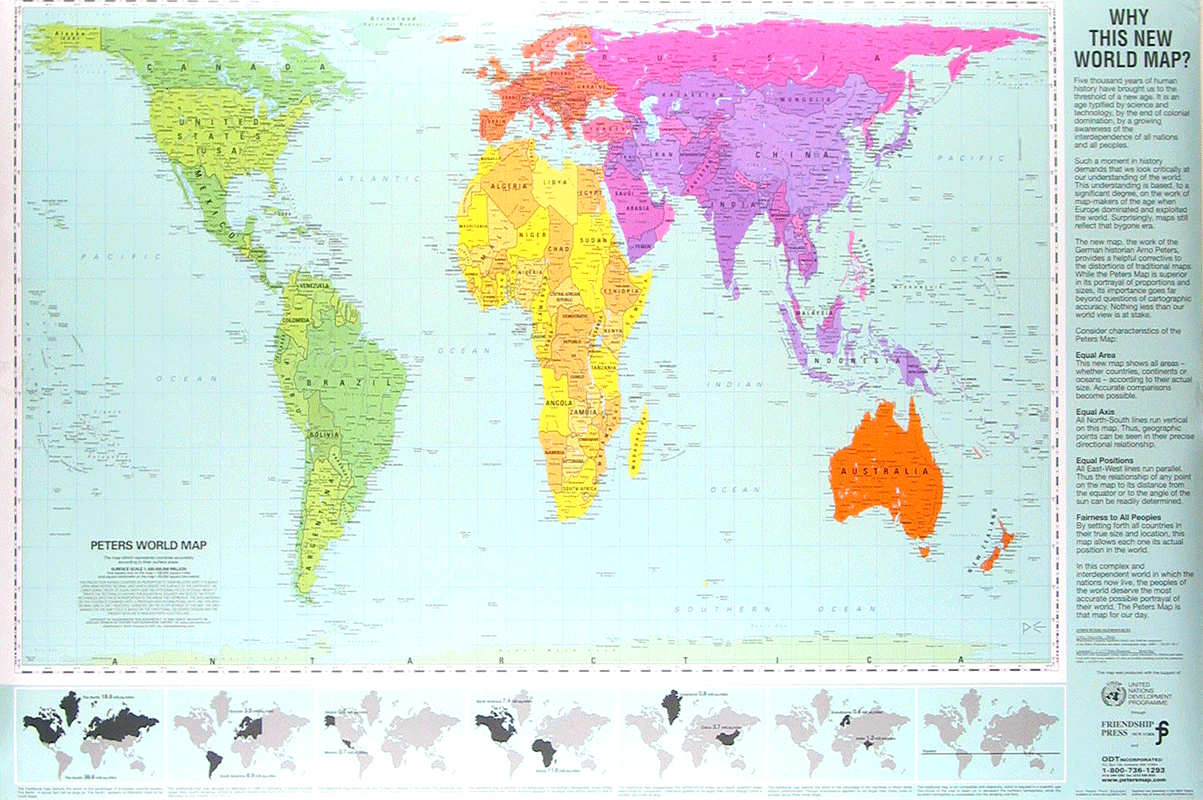
so how can it be? are we being fooled?! not really..
the problem starts when we try to take a 3D ball (our planet) and make it a 2D map. in every Technic we will use we will get some distortions. The map as we know it today first created by a a Flemish map drawer named grados martor in 1569, in the map that he drew the angles and shapes of the land kept accurate, a quality that is important for sailors, but the distortions in the map is that the more that you move away from the equator line (the horizontal grey line on googles map) the sizes and distances get more distorted and get bigger. on the top of that europe was the center of the world on the 16 century and thats why grados chose to put it the middle of the map. it is possible to put in the middle of the map every country or land that we want, and this is how people who lived in australia used to do it, put australia in the middle of the map and set the map direction as south, and not north as we use it today. the result of that as you can see is a that australia is a big land in the middle of the world, above any other land or nation.

the reason that google use this map is that most of the people use google maps to check small distances, like a ride in london, or where the hell is malta, for this kind of things the distortion is negligible.
but the reason that the world chose to use grados map as every day map we can only guess. seems that the white man likes to be in the center of the world, big and above!
this post doesn't try to make you doubt about all the knowledge u accrued over the years or in a way make you drop school. it comes to tell you, open your mind, doubt a little, not every thing that you are told or used is correct or entirely correct. doubting about things that were considered as correct led to bigger things. one of the classic and the most famous example for that is Eisenstein's relative theory that came as a replacement for newton classic mechanic theory that controlled the world over 300 years.